

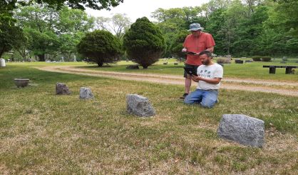
Hagar Township is working with consulting firm Wightman to update its cemetery records with a modern GIS system. Wightman GIS Manager Ryan Miller tells WSJM News the township has three cemeteries, and modern technology is being used to sort out the records and maps.
“It’s a huge challenge for some communities,” Miller said. “Some of these records are dated back to the 1800s. Over time, the records were hand written or typed in ledgers. Maps were created to lay out cemetery plots.”
But those maps aren’t always in line with the current state of a cemetery. Miller says Wightman is putting together online maps that have information on each plot. The public will be able to use them.
“We bring that into a modern mapping system and often use GPS equipment to locate corners out there that we know exist so we can match those up with the map in the system and kind of put it in its correct place on the Earth, if you will.”
Wightman is also working with Dowagiac and Antwerp Township for similar projects. Miller says over time, cemetery records get mixed up or damaged, and it can be a challenge to sort everything out. He expects the project in Hagar Township will be finished later this year.

